Summary:
- Hurricane Francine made landfall near New Orleans, LA on Wednesday, September 11th as category 2 hurricane. Winds were over 100mph, and some areas received more than 12 inches of rain. It has since weakened to a tropical storm as it moves inland.
- Hundreds of thousands of people in Louisiana are without power in the aftermath of the storm.
- All flights in and out of New Orleans were cancelled but have since resumed as the storm has weakened. The port of New Orleans remains closed as damage is assessed.
- Louisiana saw a 10% decrease to full truckload on-time performance and a volume decrease of nearly 50%. Alabama, Florida, Texas, and Mississippi are stable but continue to be monitored due to flood and tornado risks.
Overview
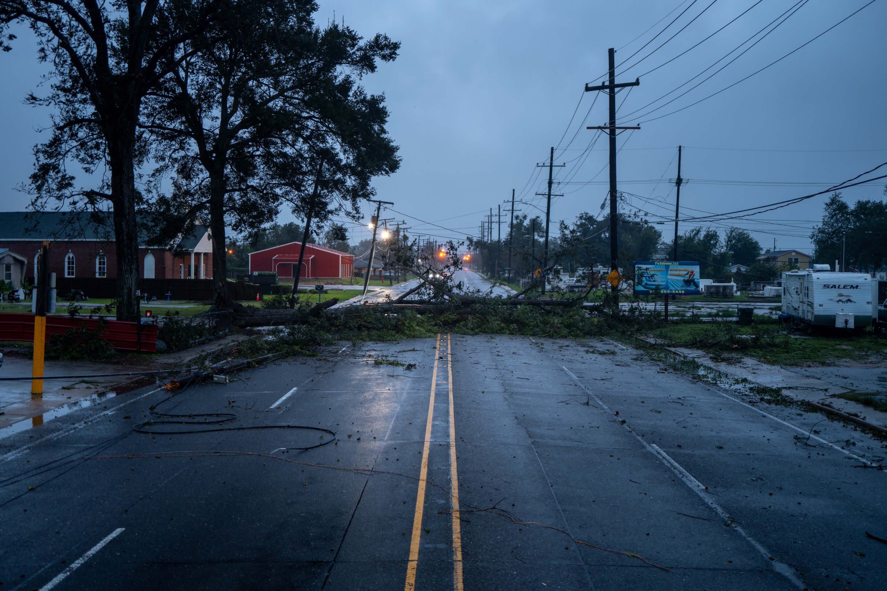
On September 11, 2024, Hurricane Francine made landfall near New Orleans, Louisiana, as a Category 2 hurricane. Winds of approximately 100 mph and heavy rainfall—up to 12 inches in some areas—caused flooding and infrastructure damage. Fortunately, the storm weakened quickly as it continued moving inland. However, heavy rains are expected across the Southeast, potentially causing further flooding, with additional concerns of tornadoes in Alabama and the Florida Panhandle.
The Port of New Orleans remains closed as of September 12th while damage assessments are ongoing. While flights inbound and outbound from New Orleans were cancelled yesterday, cancellations are already starting to dwindle and flight patterns are returning to normal. In addition, hundreds of thousands of residents and businesses in Louisiana have been left without power. First responders are working diligently to restore electricity and address storm damage. project44 is closely monitoring the situation and its impacts.
Vessels in Vicinity
The map below shows vessels near the path of Hurricane Francine.
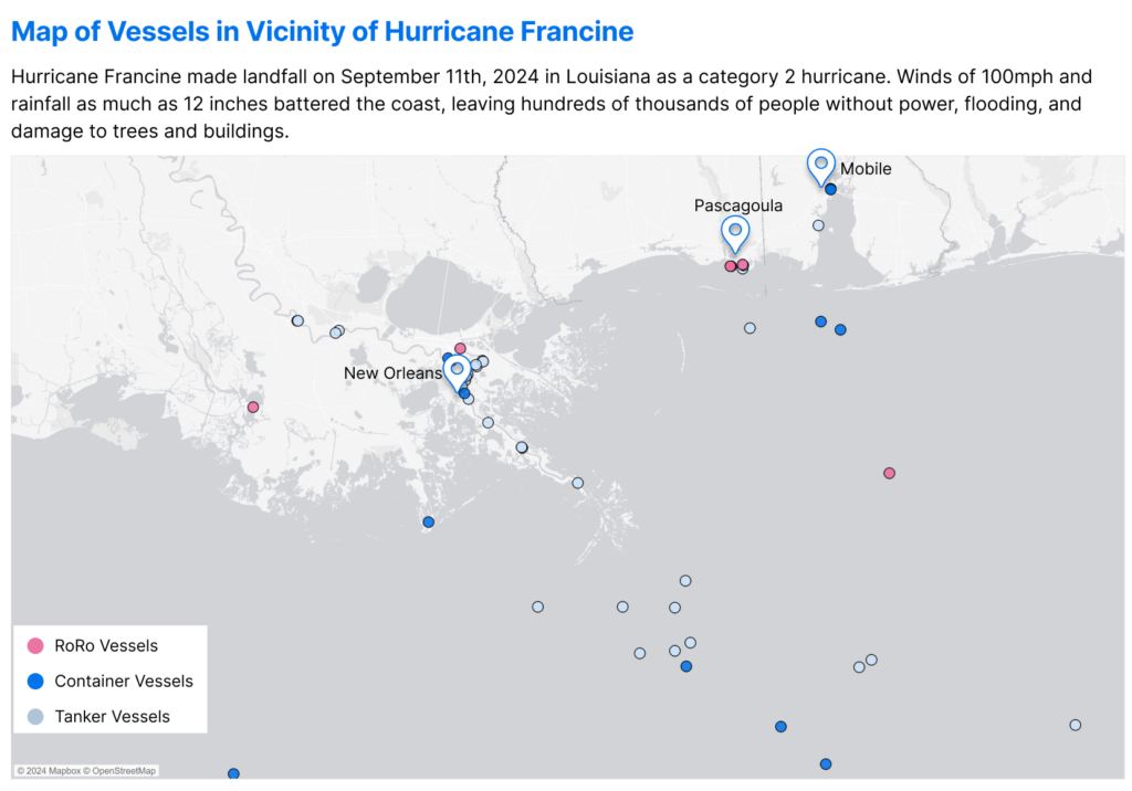
Around 50 vessels, primarily oil tankers, are currently near the storm’s path and may experience delays as they await safe entry into major ports. Vessels already in the ports may also experience delays in departure as they wait for storm conditions to clear.
Similar to Hurricane Beryl’s impact in Texas earlier in July, the U.S. oil and gas industry is likely to experience delays as Gulf Coast refineries may need to shut down or suspend operations. This comes at a critical time, as the peak season for U.S. retail imports approaches.
Ports Impacted
The Port of New Orleans has been the most severely impacted by Hurricane Francine. As the storm made landfall as a Category 2 hurricane, the port was directly in its path and remains closed while authorities assess the damage.
Since the storm weakened quickly after landfall, the ports of Houston and Mobile have not been as severely affected. Both ports are currently open and operating without restrictions. However, heavy rainfall in the coming days could result in flooding, and there is an elevated risk of tornadoes that may impact the Port of Mobile. For now, both ports are operating without significant interruptions.
The chart below shows the daily inbound container vessel counts at each of these ports from September 1st through the 11th.

Both New Orleans and Mobile did not receive any additional container vessel traffic leading up to the storm, while Houston received one container vessel yesterday. It is likely that vessel traffic at the Port of New Orleans will remain at zero until the port reopens.
The chart below illustrates the daily import dwell at ports leading up to landfall.
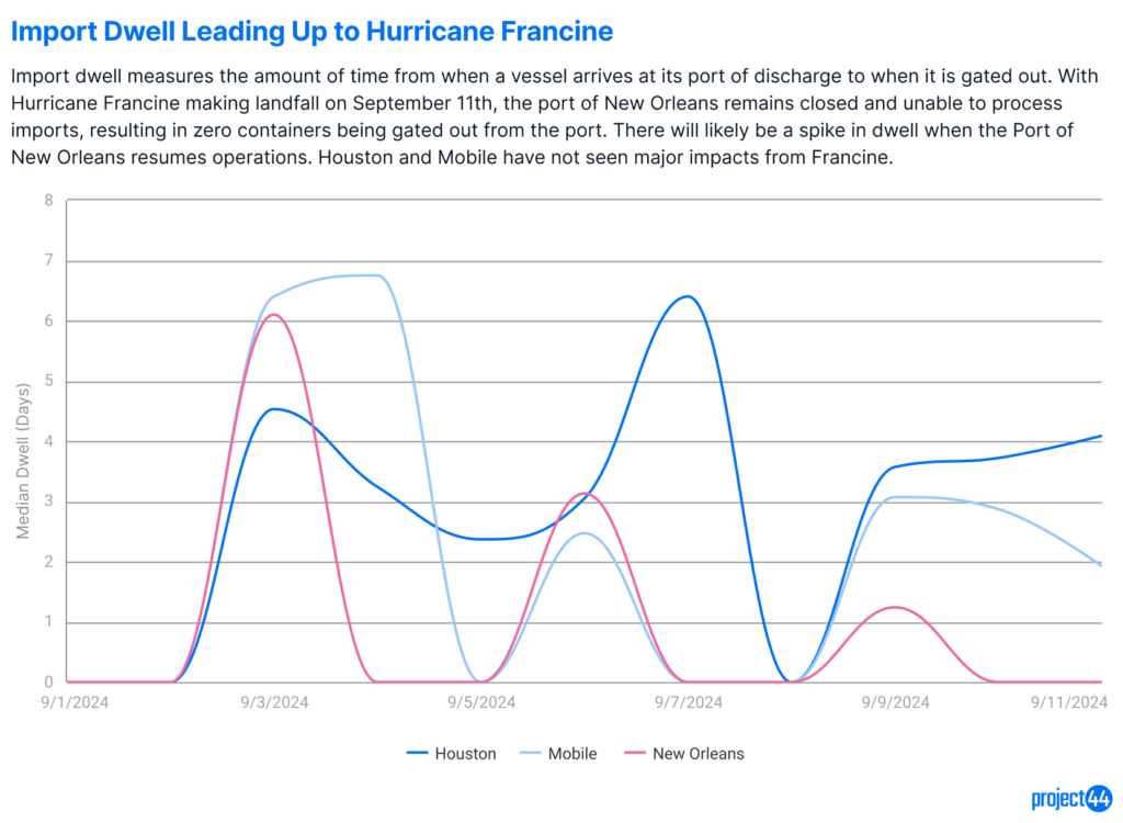
The Port of New Orleans has not processed any imports for the past two days, a trend expected to continue through September 12th and possibly longer, depending on the extent of the damage. This will likely result in a spike in dwell times once operations resume. Mobile and Houston have continued processing imports through the 11th, and with both ports remaining open after the hurricane, they are expected to experience limited disruptions to import dwell times.
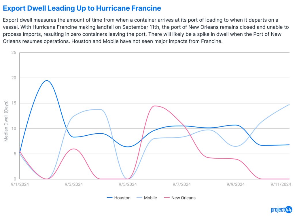
Similarly to import dwell, New Orleans has not processed exports in the past two days, and with the port closed today, it will mark at least three days without any container activity. This will lead to an increase in export dwell times once the port reopens. The ports of Mobile and Houston have continued operations and are not expected to experience major disruptions.
Truckload Impacts
Truckload shipments may face delays due to hurricane-related roadblocks and flooding. Tornadoes associated with the storm could further exacerbate these issues. Current on-time performance in the affected states is outlined below.
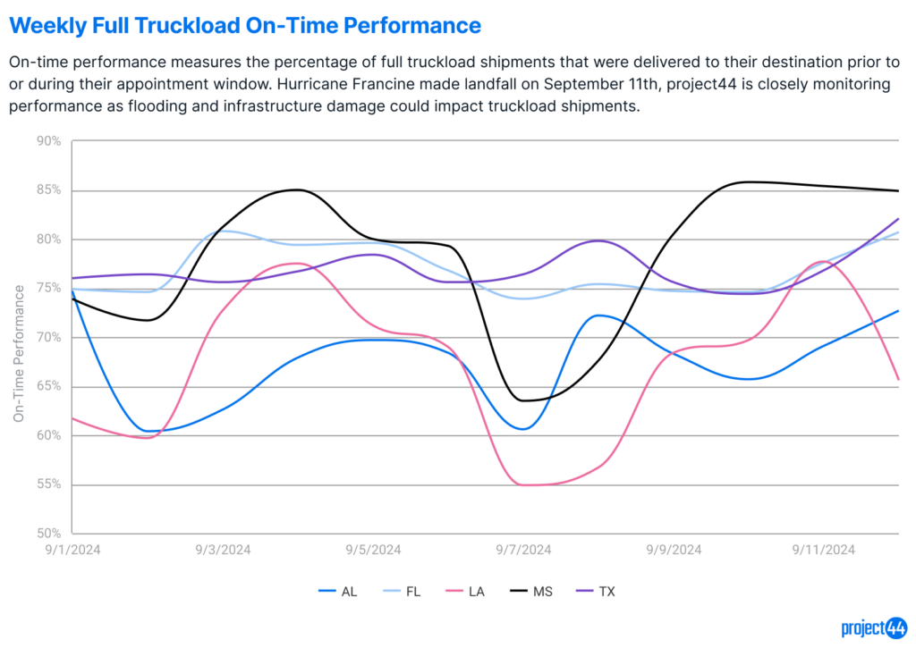
Louisiana is the only state currently showing a decline in performance levels, with a 10% drop in on-time delivery leading up to Hurricane Francine’s landfall. Additionally, there was nearly a 50% decrease in shipment volume between September 10th and 11th, similar to the 60% reduction seen during Hurricane Beryl in July. It is likely that lower shipment volumes and reduced performance levels will persist as recovery efforts, including clearing blocked roads, continue.
Alabama, Florida, Texas, and Mississippi have so far maintained stable shipment volumes and performance rates, but this could change depending on the extent of flooding and tornadoes in the coming days.
Summary
Hurricane Francine has caused significant disruption along the Gulf Coast, particularly in Louisiana, where flooding, infrastructure damage, and widespread power outages have occurred. The Port of New Orleans, directly in the storm’s path, remains closed, delaying both import and export operations. Other ports, like Houston and Mobile, have thus far been spared from major impacts and remain open, though potential flooding and tornadoes could still pose risks. With vessel delays, port closures, and roadblocks affecting truckload shipments, recovery efforts will be critical in minimizing further disruptions to the supply chain, especially as the peak retail season approaches.
Concern for Safety
While project44 has made it a priority to provide frequent updates on Hurricane Francine and its impact to the supply chain, the safety of all people impacted by the storm remains top of mind. They and their families are in our thoughts, and we urge people to follow local guidelines for safety in these times.
